

2 November 2026 Linda Pappagallo & Ryan Unks
Myth: ‘More data means better rangeland management’
Critical data studies have pushed back against the widespread belief that “large data sets offer a higher form of intelligence and knowledge that can generate insights that were previously impossible, with the aura of truth, objectivity, and accuracy”. These studies warn how big data, and data more generally, are never really objective. They need to be examined carefully to understand how they advance the agendas of powerful actors.
For this think piece, closing our year-long series of events on ‘Rangeland Myths’, we focus on some problems with dominant pleas for more data specific to rangelands.
Underlying the myth that ‘more data means better rangeland management’ is the idea that increasingly sophisticated technology can provide increasingly sophisticated data: and that this data can help us manage rangelands through more objective, universal, optimal, certain and complete representation of diverse and complex socio-ecological rangeland systems.
Recognizing this myth is increasingly important as climate technologies, ‘nature tech’ and digital Earth infrastructures expand as dominant tools for governing landscapes.
In this piece, we first explore how the ‘need’ for more data is constructed through narrative scripts that center financial solutions. Secondly, we’ll consider two complementary ways of considering problems with rangeland data through technical and critical data approaches.
Together, these approaches challenge the assumption that more, greater precision, or higher resolution data in themselves necessarily lead to better environmental governance or rangeland management.

The construction of a data-hungry narrative
The maxim “you can’t manage what you can’t measure” has become a recurring rationale for carbon developers, restoration projects and organizations promoting the need for data-centric management infrastructures. In this context, measurement is presented not merely as a means of demonstrating outcomes, but as a prerequisite for managing, valuing and scaling environmental interventions.
In particular, digital Monitoring, Reporting and Verification (dMRV) – the integration of remote sensing, geospatial analytics, and digital data workflows into the monitoring of ecosystems – is often presented as an efficient solution. These tools are more than simply a way to digitize reporting processes: they enable new ways of observing land-use change, estimating biomass, and monitoring project performance across large landscapes. They have become an important foundation for scaling market-based instruments such as soil carbon offset credits.
Data-hungry narratives are produced in the context of attracting finance: scripts of “we need to close the funding gap” and “we can do this by attracting private investment” are coupled with those of “we don’t have enough (good) data on rangelands”, and “we need to make rangelands more visible and/or investible”. Reports such as “Making Nature investible” position finance and new environmental markets at the centre of climate, conservation, and restoration. By emphasizing a funding gap for restoration, ‘nature’ is also framed as an opportunity for mobilizing private capital, developing new financial instruments, and creating investible environmental assets.
‘Unlocking private finance’ was high on the agenda at COP17, where US$1.3 billion in new finance for land restoration and drought resilience was announced, along with the launch of the $1.2 billion Rangelands Flagship Initiative. Integrated in these agendas are scripts also followed in “Making Rangelands Investible” and “closing the funding gap for rangeland restoration”, which have been asserted throughout the International Year of Rangelands and Pastoralists and spearheaded by actors such as the World Bank, IUCN, UNCCD, various development banks, WWF and national ministries.
Rangelands Rising, a follow-up report on “The Business Case for Investment in Rangelands Restoration”, further claims that “these landscapes remain almost invisible to the people who finance and govern the natural world”. On the one hand, the report helpfully dispels longstanding tropes that portray rangelands as marginal and empty landscapes, and pushes back against narratives that attribute their degradation primarily to grazing. On the other hand, its central argument – that rangelands have been overlooked “not because their value is absent, but because we have often failed to measure it properly” – risks reducing their marginalisation to a problem of information, knowledge and valuation.
This framing can reify the idea that better data and economic measurement constitute ‘solutions’ in and of themselves. This can, in turn, make it more difficult to see and intervene in the structural complexities of political-economic relations that shape how the costs and benefits of rangeland management are distributed. The issue, then, isn’t simply that the ‘value’ of rangelands has not been adequately measured. It’s that their diverse and multifaceted values are contested, and so recognised, prioritised and acted upon unevenly, according to existing power relations and economic interests.
Regardless of questions of why finance is elevated, what kinds of finance, and on whose terms, the scripts about ‘the funding gap’ and finance – scripts that imply that new, improved data will benefit pastoralism – are not neutral descriptions, but political framings. Carbon and biodiversity credits, which function as models of abstraction when coupled with market-based finance, ‘translate’ rangelands in new ways.
As we discuss below, such data and valuation systems risk systemically distorting and biasing our understanding of pastoralism. To understand how, we next take a technical and critical data science approach.
Reconsidering rangeland data and representations
Technical approaches
A technical approach asks what the data actually represent, how they were produced, what assumptions and processing steps underpin them, and how biases, omissions, and uncertainties are carried through the analytical chain. What constitutes ‘accuracy’ or ‘quality’ depends on the purpose for which data are produced and used.
Importantly, data that are technically more accurate may ironically be less meaningful for answering a given question. Greater resolution, more data points, and increasingly sophisticated algorithms do not themselves necessarily produce greater understanding. Applied to rangelands, more accurate geospatial data are unlikely in themselves to better understand relationships between ecosystem heterogeneity, variability, and dynamics, and pastoralist practices of benefitting from and managing them.
Despite frequent claims of generalization, relationships between livestock and rangelands are extremely context-dependent, and they remain difficult to study using tools like remote sensing. It remains common for studies to fail to account for the high variability of rainfall and temperature in space and time in rangelands, despite careful attention to these has increasingly overturned claims that pastoralism is the primary driver of degradation.
Other types of data, such as pastures data, commonly used to estimate anthropogenic impacts, distinguish “natural” grasslands from those where livestock graze. However, these definitions and spatial distributions of pastures are not measured, but are instead predicted using FAO livestock census data. The underlying data used to make these predictions are temporally and spatially static, mismatched in year and spatial precision, and do not distinguish production systems (e.g. extensive pastoralism vs. industrial). In turn, although these data say almost nothing about the nature of livestock use or its environmental impact, they are the basis of popular representations of dramatic expansion of livestock land use in recent decades in the global south, such as those generated by Our World in Data:
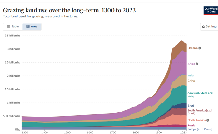
Another way of presenting livestock data more directly is the Gridded Livestock of the World, which uses the same FAO data, with the same problems, in a global, seemingly accurate dataset. Although these data don’t offer any information about livestock herding practices or relationships with ecosystems, they are regularly used to assess global, universal impacts of livestock (e.g. methane emissions, degradation, restoration, carbon storage, and anthropogenic pressure) and to recommend interventions.
These examples suggest that the accuracy of the data themselves is not the problem. But they show how the diversity of pastoralism and rangelands can be ‘blurred’ by data. This points to a related issue: in rangelands, more information is not necessarily knowledge, and more information does not always result in better prediction. Non-linear processes such as drought, how vegetation responds to rain, and human–environment relations cannot be addressed only through technical improvements to measurement. Improved satellite forecasts, early-warning systems, AI applications, and data-driven insurance products may provide additional information, but they cannot eliminate the underlying uncertainty and abstraction that happens when social and ecological variability are treated as noise to be removed.
The geospatial data considered above can create a deceptive sense of certainty about relationships between livestock and land despite not being able to consider pastoral mobility and socioecological variability. Processes of conversion, harmonization, and use of mismatched layers introduce additional uncertainty, yet these compounded uncertainties can disappear when collapsed into single figures, misleading local planners.
The point here is that datasets often entrench harmful dominant narratives about pastoralism. Resolving technical problems with data may improve particular forms of observation aligned with particular agendas, but it can also exclude pastoralist and social science knowledge.
The critical data approach
The critical data approach goes beyond understanding technical limitations by asking other key questions. What do data-driven representations of rangelands do, politically and socially? Whose knowledge is represented, whose realities, futures, and imaginaries become legible or remain invisible, who defines what counts as a problem, and who benefits from particular forms of measurement?
When we understand how the systemic, power-laden aspects of rangeland data influence ways of imagining rangelands, we can more easily see how the processes of producing data can deepen global inequities. Here we focus on ‘data illusions’ that elevate certain forms of visibility and value, while obscuring the political and ecological complexity of rangelands. These patterns are perhaps most clear in biodiversity conservation prioritization, where the tendency is to overlook the broader functional and political complexity of socio-ecological systems.
Rather than mere aberrations, glitches, or technical problems in the data, these illusions are understood as systemic. From a critical data perspective, what is rendered visible or invisible is a political decision.
Let’s take the example of remote sensing: basically, gathering information about an object from afar. Earth observation, the ‘satellite gaze’, is a choice about defining what we are looking at. Rich and diverse ecosystems, as they are perceived by pastoralists, may be seen and mapped as ‘wastelands’ by government officials. Earth observation in itself may look like a neutral tool, but it is clearly political depending on who is using it, to see what, with what definition in mind.
Similarly, data-driven environmental policy increasingly relies on using geospatial approaches to identify landscapes where interventions supposedly offer the greatest returns. These calculations also raise questions of whose values are represented.
Frameworks such as the Land Degradation Surveillance Framework (LDSF), which has been implemented across more than 45 countries, seek to generate standardised evidence that can help policymakers prioritize interventions and allocate limited resources. However, such geospatial approaches prioritize interventions based on standardised indicators of biophysical soil degradation; they rarely produce a comprehensive pastoral experience and understanding of the historical, political, social, and ecological drivers of degradation.
Philanthropists, NGOs, consultancies, and technology companies continue to invest in data-driven environmental initiatives. In this context, critical data studies can draw attention to the growing concentration of data, storage, and processing capacities, particularly in the Global North, and ask whose realities, priorities, and forms of knowledge are excluded.
Universal metrics necessarily privilege particular definitions of degradation, health, productivity, and value that become embedded in remote-sensed datasets. This introduces a layer of abstraction, where a proxy becomes a stand-in for objective reality, while concealing the assumptions embedded in measurement.
For example, remote sensing does not directly measure tonnes of CO₂ in a forest. Robert Nasi, former research director at the Center for International Forestry explains, talking about tree carbon: “Nobody has ever measured a tonne of CO2 in a forest using remote sensing. What is measured is reflectance or backscatter; from that comes canopy cover or height; from that, above-ground biomass through allometric equations, the pantropical standard being fitted on 4,004 harvested trees from 58 sites, almost none of them from the stand being credited; from that, carbon at an assumed fraction of 0.47; and from that, CO2 at 44/12. Five conversions, each carrying its own error, and the uncertainty that reaches the buyer is usually the uncertainty of the last step.”
In the context of rangelands, a fast-growing technological infrastructure (including remote sensing) allows for the ‘scaling up’ of soil carbon projects. Critical data studies understand this as ‘datafication’ (i.e the ways social life is rendered into data that can be collected, analyzed, and acted upon by governments, corporations, and other powerful actors). ‘Smart rangelands’ are reconfiguring global power relations as tech meets financial markets, and as environmental challenges and solutions are understood through (ac)counting practices.
As pastoralists are incorporated in these processes, where new data is promoted as producing better and more reliable information, and presented as a necessary condition for better herd and pasture management, the critical data studies offer caution on the unintended consequences, and draw our attention to justice, ethics, and rights concerns.
Beyond ‘more data’
The examples above show how ‘optimum’ processes of determining management recommendations and priority areas are not simply ‘found’ through data: they are produced through particular assumptions about what counts as degradation, value, urgency, and ‘rates of return’.
Recommendations to prioritise lightly to moderately degraded rangelands, for example, may appear economically and environmentally rational because these areas can offer high returns on investment. But this may distract global attention from the kind of environmental governance and safeguarding that rangelands and pastoralists really need.
The problem is not data itself. It is the assumption that data can be detached from the social, political, and ecological contexts in which it is produced and used. Uncritical use of geospatial data, and the use of data to drive interventions in rangelands, risks building a distorted reality, or a reality that exists only from one angle.
In Kenya, pastoralists have long been blamed for land degradation, and have been seen as in need of intervention to fix their grazing systems. At the same time, conservation and other practices have captured high productivity areas for wildlife and agriculture, squeezing pastoralism on to the driest, most variable land. Soil carbon projects claim to be designed with pastoralist livelihoods in mind, in a way that creates value for global north approaches to addressing climate change and biodiversity loss, offering technical solutions (e.g. better data for monitoring and policing mobility – seemingly designed to enforce another squeeze) produced by powerful NGOs.
But it is clear that simply expanding one way of seeing and making it more accurate is not the solution. We need new ways for ensuring that data and their analysis strive to include fundamental aspects of pastoralism, to be transparent about the limitations when they cannot, and to prevent data from extending harm in new ways. Critical ways of co-producing geospatial analysis with pastoralists, or triangulating between pastoralist expert knowledge, social scientists, and dryland landscape ecologists may help to work against power imbalances.
What we need is more ways of seeing, not better ways of seeing the same.
 Want to discuss myths about data? Join us online for our ninth and final rangeland myths conversation of 2026, on the myth that ‘more data means better rangeland management’, on Thursday 3 December.
Our speakers are Mike Davies (Social Carbon), Ryan Unks (UAB/CONDJUST) and Masresha Taye (African Development Bank), and our co-chairs for the discussion will be Dan Brockington (ICTA-UAB) and Adrian Nel (University of KwaZulu-Natal).
We warmly invite anyone with an interest in rangelands, pastoralism and myths about them, to join, share your stories and rethink how we ‘see’ rangelands and pastoralism.
Related posts
27 December 2025 Amber Huff & Linda Pappagallo
Rethinking what we think we know about rangelands and pastoralism
In this introductory blog on ‘rangeland myths’ we emphasise the need to rethink what we think we know about rangelands and pastoralism in ways that are open to diverse perspectives, experience and knowledges.

5 December 2025 Amber Huff & Linda Pappagallo
Exploring rangeland myths in 2026
Through 2026, the REPAiR is hosting a series of activities that explore ‘rangeland myths’ in global perspective. We offer an open invitation to get involved, share your experiences and stories, and help us to rethink what we think we know about rangelands and pastoralism.